To: Senators of Public Lands and Forests sub-committee
Submitted by: Nancy Freeman, Executive Director
Groundwater Awareness League, Inc.
P. O. Box 934
Green Valley, AZ 85622
Date: June 16, 2009
Subject: Southeast Arizona Land Exchange and Conservation Act of 2009
Senate Bill S.409
I am contacting you because you are a member of the Public Lands and Forest sub-committee, which will be hearing Bill S.409 on Wednesday, June 17. As a resident of Arizona, I am concerned that the U.S. Government is giving away beautiful, scenic, recreational land that also has a historical and cultural significance for the local Native Americans.
Land exchanges were created for the purpose of serving the public good, such as consolidating endangered species habitat, acquiring environmentally sensitive areas, or preventing undesirable development. Another reason has been to give up plots of land that are isolated and thereby hard to manage and to consolidate other plots. However, this practice does not forego the basic purpose of “for the public good.” None of items on Bill S.409 meet any of the above criteria. Further, we have to question why Resolution Copper is taking the legislature route rather than the standard administrative public process by which 99% of land exchanges occur. We have never been told the true purpose behind this land exchange.
The progenitors of this Bill have contacted or met any of the local Nations. Neither have they visited any of the sites that are being considered in the exchange—for none of them are significant. They are useless, over-grazed ranches that were sold to the mining company at fire sale prices (one of them actually was burned out).
I am requesting that Senator McCain disclose how much of the $210,813 political contributions from mining companies in his 2008 campaign was received from Resolution Copper, BHP and Rio Tinto, or any of their subsidiaries. Further, I am requesting that Senator Kyl disclose how much of the $82,823 political donations in his 2006 campaign was received from Resolution Copper, BHP and Rio Tinto, or any of their subsidiaries.
The records show that Rio Tinto and BHP (with their subsidiaries) are two of the worst polluters on the planet. Near the Salt Lake in Utah, Kennecott (Rio Tinto subsidiary) has one Superfund site and one that was just moved from the potential Superfund list. In Arizona BHP has the equivalent of a superfund site at Pinto Creek, in the region of the proposed Resolution Copper mine.
Here in Arizona, we value these special places, for recreation and for wildlife. Oak Flat is a special place for bird watchers; the campground billboard warns that it is bear territory. Nearby Devil’s Canyon is also a unique treasure for rock climbers and birders.
The Oak Flat site is in the Tonto National Forest, which has only 1% of riparian area to give water to the wildlife. In fact, a special Riparian Area Program has been created to protect, enhance and restore riparian areas there. If this land exchange occurs, the crucial riparian region of Devil’s Canyon will be dewatered, while the public will be paying for riparian restoration elsewhere. The mining operations will have to pump water out a region a mile in diameter. This pumping is sure to rob the trees and vegetation in the whole region of water to sustain themselves. See attached report for hydrological details. (Attachment One)
Most of you have no idea of the impacts of mining: high water usage, waste piles 100’s of feet high, sulfuric acid leach facilities, dust control, and the converting of a scenic highway into a haul road for huge trucks to carry ore to the smelter. However, they are a reality in polluting air, water and soil.
The mining company and some Arizona legislators think that it is worth it for the money brought in for jobs. However, the jobs formula does not hold up when one analyses the small percentage that the jobs represent in comparison to the overall profits to the corporation. (See Attachment Two)
President Eisenhower was wise in protecting this area. The local story is that Mamie Eisenhower went on a picnic there during a Presidential visit to Arizona and twisted his arm to protect it. The area has been protected for some 50 years now. Successfully, for the campground billboard warns that it is bear country. It’s always some 20 degrees cooler than Phoenix, which is only an hour away, so it’s also a cool haven in the summertime for city dwellers.
Attachment One: Hydrological considerations at Oak Flat and nearby Devil’s Canyon riparian habitat
The important issue of the dewatering of the Apache Leap Tuft is a concern in the proposed Land Exchange at Oak Flat. At present, water, which sustains Oak Flat, the surrounding oak forests, and the unique Devil’s Canyon flora, is protected by Federal Law. The Doctrine of the Federal right to water in public lands was established in 1908 by Winters v.
A case in 1999 in Arizona Supreme Court reasserted the Federal right to water in public lands is still in tact. The presiding judge wrote, “The [Winters’] doctrine applies not only to Indian reservations, but to other federal enclaves, such as national parks, forests, monuments, military bases, and wildlife preserves.”
www.g-a-l.info/AZAdjudication.htm
An understanding of the groundwater hydrology in the entire region is fundamental to comprehending the effects that dewatering the tuff by mining operations will have in the region. The tuff overlays the entire area proposed to be mined and extends up to Top of the World. The tuff is actually a steep escarpment of volcanic ash flow. The ash flow tuff, named after the Apache Leap cliffs, at one time covered approximately 1000 km2 in the
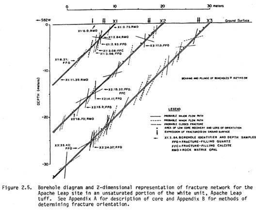
The tuff at the field site has a matrix porosity of approximately 17.5% and contains numerous near-vertical fractures at an average spacing of 1.3 m. More than 270 m of 6.4-cm-diameter oriented core were collected from boreholes drilled to a maximum depth below the surface of 30 m and at a vertical angle of 45°.
Apache Leap Tuff is classified as an a sh flow tuff. The cohesion of molten glassy shards and pumice fragments results in significant vertical variations in the physical properties within individual flows. Porosity and permeability of these conglomerates can vary from 70 percent in non-welded zones to less than 5 percent in welded zones.
These significant vertical variations are important in the mining operations at the proposed Resolution Copper mining site. The old pumping records of Magma mine will verify that after rain events the shafts had to be pumped to dewater them. The large amount of water that had collected in Shaft Nine also indicates that the surface water does infiltrate through the tuff in paths that are irregular and unpredictable.
Hammer and Peterson (1968) (2) noted two primary sets of faults in the Superior region. The first and oldest set trends principally to the east and is mineralized. The younger, second set trends generally north to the northwest. Overall, these faults are less mineralized, more dominant and offset the first set of faults and older rocks .
The extensive hydrological research done on the Apache Leap tuff has been funded by the U.S. Department of Energy in an effort to determine if tuff-type material was suitable for storage of radioactive waste. Proposals to use thick unsaturated zones of ash flow tuff such as Yucca Mountain in the Nevada Test Site of the southern Great Basin for high level prompted the studies and funds from the Federal Government. The studies were to identify mineralogical changes and measuring isotopic variations to establish the history of climatic and geo-morphological processes that might affect the isolation properties of a waste repository site, and to obtain information on flow patterns in unsaturated and saturated fractured rock of low permeability.
The major hydrological work was done in 1988 : Stable Isotopes of Authigenic Minerals in Variably-Saturated Fractured Tuff (3) www.osti.gov/bridge/servlets/purl/60500-ybLaTR/webviewable/60500.pdf
The information was targeted for mineralogical and isotopic analysis included: distinction of flow paths, mixing, and variability; paleoclimatic information; and natural water-rock interactions. Following is a graph of the fracture zones in the region of study.
A brief description of the hydrogeology of the Superior area is given on pages 17-23 of this report. The discussion includes a narrative about the rates of pumping from the Magma shaft #9 - 450 gpm with peaks up to 1200 gpm, and other wells that might influence groundwater distribution in the area, and briefly describes several springs in the region and concludes with a comment about pre-Magma water levels in the area.
The report states that additional research should be able to identify more recent discussions of the regional hydrogeology and more fully document the impact of past dewatering from the shaft and other boreholes on groundwater, springs and surface water in the area of concern. The report further states that the Magma shaft dewatering and the other boreholes in the area appear to have radically changed the groundwater system in the Apache Leap Tuff.
In other words, the current reports on the region are plentiful. There is no justification for any further disturbance, which is sure to create more rifts and fractures in the tuff.
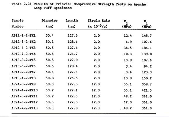
In fact, there is no mention of the environmental hazards of heavy drilling equipment on the tuff. The University of Arizona has also conducted a study (4) to determine the strength criterion that would best represent the failure of the tuff.
(1) T. C. Rasmussen, D. D. Evens, P. J. Sheets and J. H. Blanford, 1993, Permeability of Apache Leap Tuff: Borehole and Core Measurements using water and Air, Department, Department of Hydrology and Water Resources, University of Arizona, Tucson www.hydrology.uga.edu/rasmussen/pubs/WRR1993b.pdf
(3) D. S. Weber, D. D. Evans, 1988, Stable Isotopes of Authigenic Minerals in Variably-Saturated Fractured Tuff, Department of Hydrology and
Attachment Two: Resolution promises jobs, but who is really going to benefit?
The copper content is exceptionally high in the proposed underground pit that will encompass one mile in diameter. The company proposes to remove 100,000 tons a day from the underground pit. At 1% copper content, this tonnage translates to two million pounds of copper per day.
At the present price of copper— $2.20 a pound—the company will gross $4,400,000 per day, or $132,000,000 monthly. Using numbers from other Arizona copper mines, site production and delivery costs amount to about $1.50 per pound, which will run some $3,000,000 daily expense, or $90,000,000 monthly expense
The estimate is high, for since 1983 when President Reagan, Wharton School of Business and Phelps Dodge conspired to end unions in Arizona, mining salaries are no longer considered high wages. For example: 1) Entry level truck driver - $33,300; 2) Shovel operator - $46,000; 3) Journeyman electrician - $54,400.
Most mines in Arizona operate with copper at .25 percent. With these large amounts of copper hitting the market, will the other copper mines be able to continue to operate? These considerations should be factored in by our Arizona Congresspersons who are backing a bill to give Oak Flat and the surrounding region to the mining company in exchange for some over-grazed ranches. Senate Bill S.409 will be heard in committee on June 17; while House Bill H.R. 2509, introduced by Ann Kirkpatrick without meeting with the retired miners group or the local Native American Nations, has yet to be scheduled for hearing.
Profit in terms of price of copper:
Copper Daily Daily Monthly Monthly Monthly Annual
Price Tons Gross Profit Gross Profit Expense Profit Profit
$2.00 x 2,000,000 = 4,000,000 x 30 =120,000,000 -100,000,000 = 20,000,000 x 12 = $ 240,000,000
$2.50 x 2,000,000 = 5,000,000 x 30 =150,000,000 -100,000,000 = 50,000,000 x 12 = $ 600,000,000
$3.00 x 2,000,000 = 6,000,000 x 30 =180,000,000 -100,000,000 = 80,000,000 x 12 = $ 960,000,000
$3.50 x 2,000,000 = 7,000,000 x 30 =210,000,000 -100,000,000 =110,000,000 x 12 = $1,320,000,000
$4.00 x 2,000,000 = 8,000,000 x 30 =240,000,000 -100,000,000 =140,000,000 x 12 = $1,680,000,000
$4.50 x 2,000,000 = 9,000,000 x 30 =270,000,000 -100,000,000 =170,000,000 x 12 = $2,040,000,000
$5.00 x 2,000,000 =10,000,000 x 30 =300,000,000 -100,000,000 =200,000,000 x 12 = $2,400,000,000