Groundwater Awareness League
P. O. Box 934
Green Valley, AZ 85622
520/207-6506
contact@g-a-l.info
www.g-a-l.info
To: Natural Resource/Public Lands Sub-Committee
Submitted by:
Nancy Freeman
Groundwater Awareness League
Executive Director
Date: October 30, 2007
Subject: HR 3301
There are several serious considerations why the land exchange proposed in HR 3301 is not a good plan for the Arizona public or the Native Americans in the region.
1) U.S. mining companies always go through the National Environment Policy Assessment (NEPA) to be able to mine on public lands. Why should Resolution with the legacy of its parent corporations' horrific environmental records be an exception? Particularly, in this region, there are environmental issues that must be addressed adequately with a public process.
2) Tailings Disposal: There is no place to put the waste tailings, which will amount to a pile equivalent to a 20 story-building spread over 2,389 acres.
3) Resolution Copper projects a use of 40,000 acre feet = 13 billion gallons of water per year. The Superior area does not have this amount of groundwater. If water is pumped, it will threaten streams, vegetation and wild-life habitat in the area. The old small-scale mining operations of Magma and the town of Superior had/have a water supply from 15 miles away near Florence. Resolution has contracted for up to 36,000 af per year of CAP (pipeline from Colorado River) excess water – WHEN and IF it is available.
4) In 1955, by executive order, President Eisenhower protected the Oak Flats area from mining, thereby preserving this unique place from the destruction of mining operations. In alignment with this order, six Apache tribes signed and sent a letter to President Bush on June 20, 2007, asking him to protect Oak Flat, Apache Leap and Devils Canyon from mining. In July, 2007, an internet petition was started to support the coalition letter to Pres. Bush. That petition presently has 3,620 signatures supporting the Arizona tribes’ request.
http://www.petitiononline.com/coop2468/petition.html
5) Cavity size: The underground cavity is estimated to be a mile in diameter and 3,000 plus feet high. Is there an insurance company that will provide insurance there will be no collapses or air blasts? Recent history has shown that tunnel mines are the most dangerous.
6) The proposed mine site is in an incredibly beautiful area of Arizona, with oaks, riparian areas and a stream that provides a home to hundreds of sycamores, birds and other wildlife. It is claimed that the private lands for exchange contain endangered species. However, I have inquired of the Nature Conservancy and Senator Kyl for a list of the endangered species on the exchange lands. I have not received a reply from either party.
7) The nearby Apache Leap, a site of history of Native American heroes, should be protected and not be disturbed. The site should be made a national monument to honor 75 Apache warriors who exercised their freedom in a leap of faith that nothing could be worse than the capture by the U. S. Calvary.
For a full and comprehensive analysis of the situation, see the report that was sent out to all Arizona Representatives and Senators on July 24, 2007.
Why am I concerned? I live in mining territory and know what it does to the territory. I have spent over 1,000 hours collecting data and attending hearings, so that a local copper mine would stop its pollution to the water that is delivered in my own home. A picture is worth a thousand words. A bird’s eye view is available on Google maps.
Elaboration on points 1, 2 and 3:
1) Necessity of NEPA process: For some 25 years, U.S. companies have been mining on public lands with public process and environmental oversight. Records show that even with the NEPA process, there are serious contamination to groundwater, soil and air. See environmental impact report. Why should Resolution Copper, a subsidiary of Rio Tinto, whose Kennecott operations have created the biggest groundwater toxic plume in the U.S. at Salt Lake region of Utah, be granted the ability to mine without public process and oversight? This week a report was released that a Rio Tinto/Kennecott operation in Nevada is accused of inaccurate mercury reporting in an AP release.
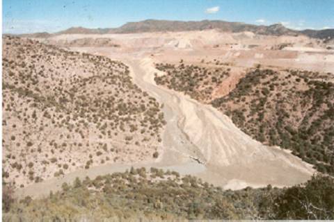
In 1997, a massive blowout of the sulfuric acid leach pads into Pinto Creek’s adjacent riparian watershed occurred at the BHP copper mine just a few miles east of Resolution Copper’s proposed mining site. Pinto Creek empties into the Roosevelt Lake, which provides a potable drinking water supply. See photo below:
Further, since this area is owned the other parent companies, BHP, Resolution Copper officials have proposed that they pipe the tailings waste up to this region, which is already a WQARF (Water Quality Assurance Revolving Fund) site.
For further information, see www.g-a-l.info/Remedial Action.htm
2) Tailings Disposal
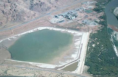
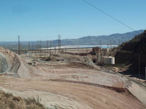
There is no place to put the waste tailings without spoiling the landscape for several miles. Augusta projects that they will be processing 110,000 tons of ore per day. Since the ore only has 3% copper, this means that daily there will be some 100,000 tons of waste to dispose of. When put in a pile 200 ft. high (20-story building), it will require 2,389 acres for disposal over the life of the mine. The tailings impoundment in my home town of Green Valley covers 3,600 acres and grows higher by 8 to 10 feet per year. See below:
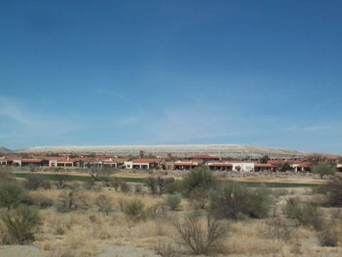
3,600 acre tailing impoundment at Sierrita mine, Green Valley AZ
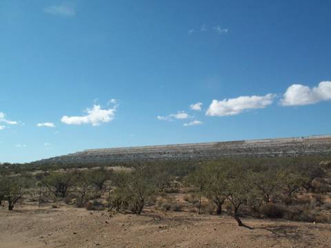
Another view of Sierrita impoundment
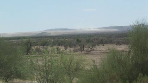
Dust blowing off of Asarco Mission impoundment near Tucson, AZ
Arial view of an impoundment and operations
Impoundment in Morenci, AZ that was cited and fined by the
U.S. Justice Dept. in 2005 after dozens of migratory birds
died from drinking acidic water.
3) Water Depletion: Mining has caused or contributed to depletion of water tables throughout the southwest. Where I live in Green Valley our water table has gone down 2 to 3 feet per year, causing a deficit of 30,000 acre feet t per year, since Sierrita mine started its open pit mining in 1970. When the groundwater recedes, the land is compacted and natural recharge from rain does not reach the deeper groundwater levels. Therefore, currently, our water deficit is 40,000 acre feet per year.
A short report on water depletion in Arizona and the Southwest